2TrackMe – Feature-rich Map application for Palm OS is out
Deutsche Beschreibung ist weiter unten.
Now it starts selling: 2TrackMe 1.0 is out. You can grab your copy here and also buy your registration code for ‘AppStore’-like 5€. I hope to have it soon also on mobile2day.de and palmgear.com and eventually on mobihand.com in a couple of days.

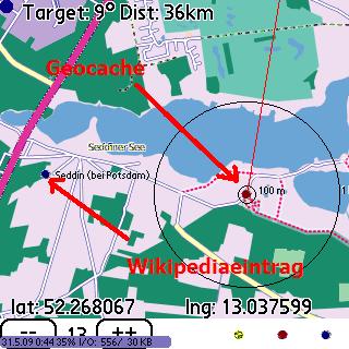
2TrackMe 1.0 offers a rich map view with maps from the OpenStreetMap project which can be fetched online when needed or stored offline on the memory card. It displays wikipedia entries close to the current location, can call geocaching.com with your current position and displays the content (GeoCaches) of the LOC file, which you can download from there.
Using the services offered around the OpenStreetMap project you can use 2TrackMe to search for any location registered in the OSM database (GPS->Guess Position) and get a route between 2 points (View->Routing).
On the main view of 2TrackMe you have the possibility to start capturing the GPS data as NMEA log on your memory card. Use this to map missing parts inside the OSM project. At the moment, you will need to convert from NMEA into GPX Track format using any of the online or offline GPS converter tools.
Using 2TrackMe you can create geo-tagged pictures. Just open the menu and select Options->Take Picture.
If you are in the mountains and don’t trust the altitude reported from your GPS device, ask the NASA for the ground altitude they have stored for your current location: GPS->Ground Alt.
If you don’t have a GPS device with you but using a GSM-Centro device, try to guess your position using your current GSM cell info: GPS->Guess Position.
If your current area is rather bad covered from OSM, open Google Maps for Palm centered on your current position: View->To Google Maps.
These are just some ideas what you can do with 2TrackMe. Don’t forget to read the online help: Help->Tips.
Enjoy,
Henk
German translation of online help / Deutsche Ãœbersetzung der Online-Hilfe
Es gibt 3 verschiedene Ansichten:
Hauptansicht (Main) mit einigen aktuellen Infos vom GPS-Gerät in einer Cockpitansicht.
Geschwindigkeitsansicht (Speed), die einem erlaubt, die aktuelle Geschwinidgkeit zu überwachen
Kartenansicht (Map), welche die Karten vom OpenStreetMap-Projekt darstellt, zusammen mit zusätzlichen Informationen (Wikiepediaeinträge, Geocaches, Routen etc.), die aus dem Internet heruntergeladen werden können.
Die Menüeinträge
Wenn Sie einen track aufgenommen haben, vergessen Sie nicht, ihn beim OpenStreetMap-Projekt hochzuladen und fehlende Strassen und Wege zu erfassen: www.openstreetmap.org.
Um einen NMEA in das GPS-format zu wandeln, können Sie z.B. http://www.gpsvisualizer.com/gpsbabel/ benutzen.
 Juni 1, 2009
·
  admin ·
  One Comment
 Posted in: Allgemein

One Response
TamsPalm Deutschland» Allgemein Leitartikel » Gewinnspiel: 2TrackMe + TouchLauncher - Juni 15, 2009
[…] gewinnen gibt es 2 Lizenzen von 2TrackMe und 2 Lizenzen von TouchLauncher. Die 4 Gewinner werden kurze Zeit nach Gewinnspielende am Montag, […]
Leave a Reply
You must be logged in to post a comment.