Mobile companion for GPS-Track loggers
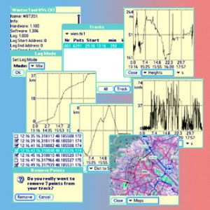
WintecTool 2.4 is now released with its new possibilities to extract infos from your track log. There are graphs of altitude, velocity, accumulated distance and direct distance from start point plotted over time or accumulated distance. These graphs are very useful to find wrong track points and with your stylus you can select and remove them from your track.
In case you have a bunch of wrong points, there is a list of all track points. Using the time info from the graph you can find the wrong points and remove them as group.
Finally you have a map view where your track is drawn over a map. The map is rendered using a free OSM renderer. When you are done with it, the track will be saved as a new file and can be further converted into other formats or used to create a GoogleMaps html file.
To make these new feature available to a brought range of GPS-Track loggers, I’ve added a NMEA import. The import feature even takes the reported accuracy ($GPGSA) into account and therefore produces good tracks in most cases.
Do you want to give it a try? You have 14 days for testing. Look here for the download.
 November 26, 2008
·
  admin ·
  No Comments
 Posted in: Allgemein


Leave a Reply
You must be logged in to post a comment.